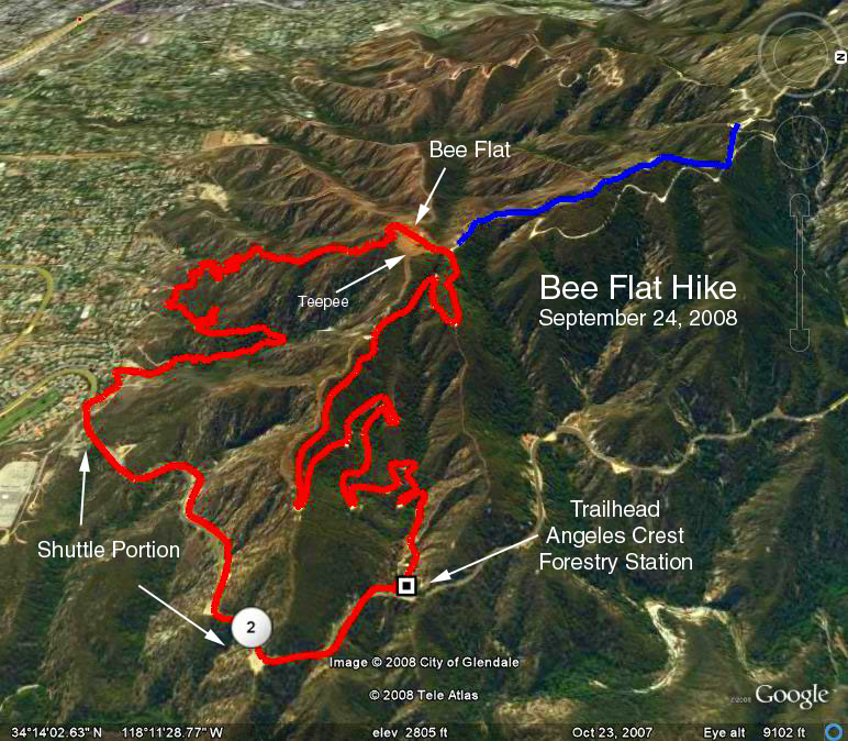
Summary: Begin at the Angeles Crest (Fire) Station 3.1 miles above the 210 Freeway, on Angeles Crest Highway. Proceed up the fire road 2.2 miles to Bee Flat or tepee just beyond. For the shorter version of the hike, return as you came for a total of about 4.4 miles. Alternatively, proceed on the well defined, but reasonably steep trail, down the front of the mountain to a lower end point on the highway, resulting in a hike of about 5 miles. A car shuttle will then be required to get you back to the party. There are no restrooms at the trailhead or park, patronize one of the businesses on Foothill Blvd.
Trailhead Directions: From the 210 freeway, exit at Angeles Crest Highway (north). Note your odometer reading as you exit, and again at 0.8 mile above the freeway, Glenola Park, which will be the site of our party.
At 2.0 miles there will be a parking area on the right side which is opposite the driveway for the ranch at 5857 Angeles Crest Highway. The longer version of the hike will finish at this point by exiting the hiker passage just above the gate which blocks the ranch driveway.
Continue up to Angeles Crest Forestry Station at 3.1 miles. Parking is available on both sides of the highway.
The hike: Proceed up the significant fire road that starts at the Fire Station. It is consistently upward so take it easy. After about 1 mile, after a long reach to the east, you will arrive at an overlook that is beneath the north/south power lines. Pause a minute, view the city, and note how the power lines terminate at the power station far below. Note different east/west power lines that also enter the station. The point where these east/west lines cross the highway is the end of the longer version of this hike.
Continue up, and the trail turnoff to Bee Flat is obvious and signed. If the killer bees or Indians harass you, telling them youre a friend of Chingachgooks, should mellow them out. Theres not much shade here. At this point the shorter hikers may return the way they came down to the Fire Station.
Those continuing, should pass the tepee by about 20 yards, turn right, and take the trail down the front of the mountain. From this point on it will be all left turns: at two tables, at Carolines Crossing, at the trail sign, at the east/west power lines, at the T (complete with sign which indicates 1.5 miles to the highway). At this point you will gain elevation to cross the ridge into Gould Canyon. You will go quite a bit north as you drop into the heavily wooded Gould Canyon, and then turn south down the other side of the canyon. In order you will pass: a yellow private property sign, a fenced junction (again stay left), stables, debris basin. At this point, for the first time, you pass under the east west power lines. Follow the road and walk down the Johnson ranch driveway to the Angeles Crest Highway.
Disclaimers: Ive hiked it, and its harder than the distance would lead you to believe. Distances are estimated, as is the elevation gain to the Bee Flat cutoff of 1000 ft. Remember all of the stay-lefts, dont come down the wrong canyon. You get about three chances to cross under the east/west power lines too early, dont do it.
If the tigers want more, I would suggest an excursion further up the fire road along the ridge, before returning to Bee Flat.
GPS Data:
One way (red trace) = 4.8 mi.
One way add-on (blue trace) = 1.3 mi.
Road Shuttle = 1.3 mi.
Trailhead Elevation = 2235 ft.
Max Elevation = 3216 ft.
Max Elevation Change = 980 ft.