Hike #1317
May 3, 2017
Malibu State Park
Joanie Schugel, Hike Leader
Directions to Trailhead: The entrance to Malibu State Park is accessed from Las Virgenes Road, 0.2 miles south of Mulholland Highway. Those coming west on PCH should turn north on Malibu Canyon Road, which becomes Las Virgenes Road. From Highway 101 going west, turn south on Las Virgenes Road. There is an $11 parking fee (car pool!!!) and restrooms at the trailhead.
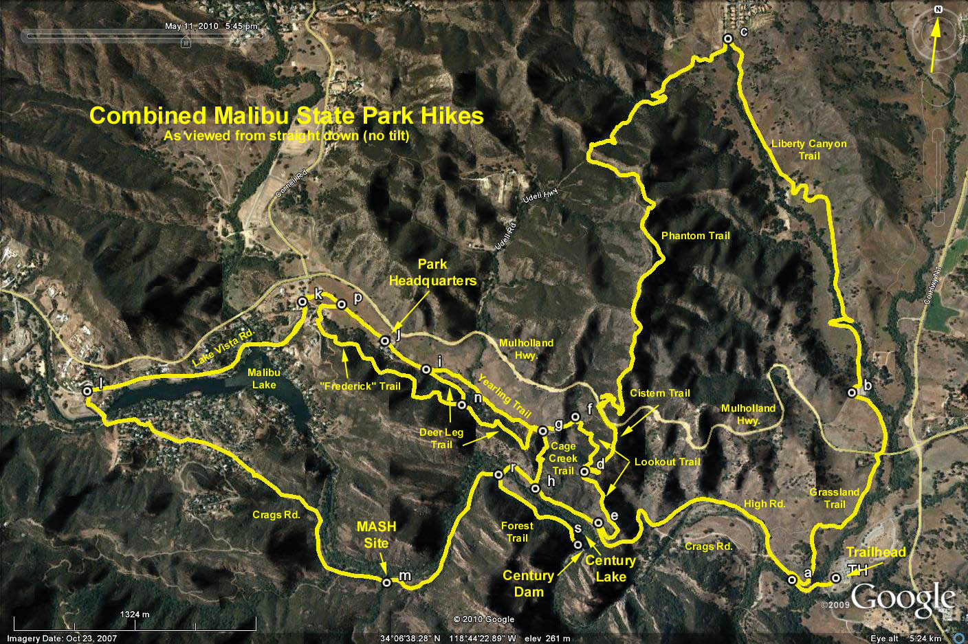
The Hike: There are many trails in the park, and we have hiked over all of them. Using GPS data in the table below and the linked Google Earth photo to indicate the leg locations/incremental distances, many loop hikes can be done from and back to the parking lot.
Google Earth photo - Malibu State Park
Distance: Up to 9 miles RT.
Elevation gain: 1100 ft.
| Leg | Route | Mileage |
| TH-a | Trailhead to Grassland Trail | 0.3 |
| a-e | Grassland to Liberty Canyon Trail | 1.1 |
| e-d | Part of Lookout Trail to Cistern Trail | 0.4 |
| d-f | Part of Lookout Trail to Yearling Trail | 0.4 |
| f-g | Part of Yearling Trail to Cage Creek Trail | 0.2 |
| g-i | Yearling Trail | 0.5 |
| i-j | Yearling Trail to Park Headquarters | 0.2 |
| j-p | Headquarters Road to Frederick Trail | 0.2 |
| p-k | Frederick Trail jct. to Lake Vista Road | 0.1 |
| i-n | Part of Deer Leg Trail to Frederick Trail jct. | 0.2 |
| n-g | Balance of Deer Leg Trail | 0.5 |
| g-h | Cage Creek Trail | 0.3 |
| h-e | Part of Crags Road | 0.3 |
| h-r | Part of Crags Road to Forest Trail | 0.2 |
| r-m | Part of Crags Road to MASH Site | 0.7 |
| m-l | Part of Crags Road to Lake Vista Road | 1.6 |
| l-k | Lake Vista Road | 1.4 |
| d-c | Phantom Trail | 2.8 |
| c-b | Liberty Canyon Trail | 1.8 |
| a-b | Grassland Trail | 1.0 |
| r-s | Forest Trail | 0.4 |
| n-p | Frederick Trail | 0.9 |
2017-03-27