Hike #1316
Aliso & Wood Canyons Wilderness Park
April 26, 2017
Bob Singer, Hike Leader
Directions to Trailhead: Take the 5 South (from the Valley and from north O.C.) or the 405 South (from the coast cities) past the "Y" junction where the 5 and 405 merge. Exit the 5 at El Toro Road, turn right on El Toro for about 1 mile to Moulton Parkway, turn left on Moulton and go about 1 mile to Glenwood Drive, turn right on Glenwood (which will become Pacific Park Drive) for about 1.5 miles, turn right on Canyon Vistas. Go about 1/2 mile until it reaches its end at Silkwood. Park by the corner here at Canyon View Park, where we will gather for the hike. Parking is in the streets of the neighborhood and there is no parking fee. The Wilderness Park is accessed through the city park.
A somewhat shorter route if you wish to pay the toll is to take the 73S toll road from the 405, exit on Glenwood Drive / Pacific Park, turn right on Pacific Park and shortly turn right on Canyon Vistas. Follow the directions above to drive to the bottom of the hill and park on the street.
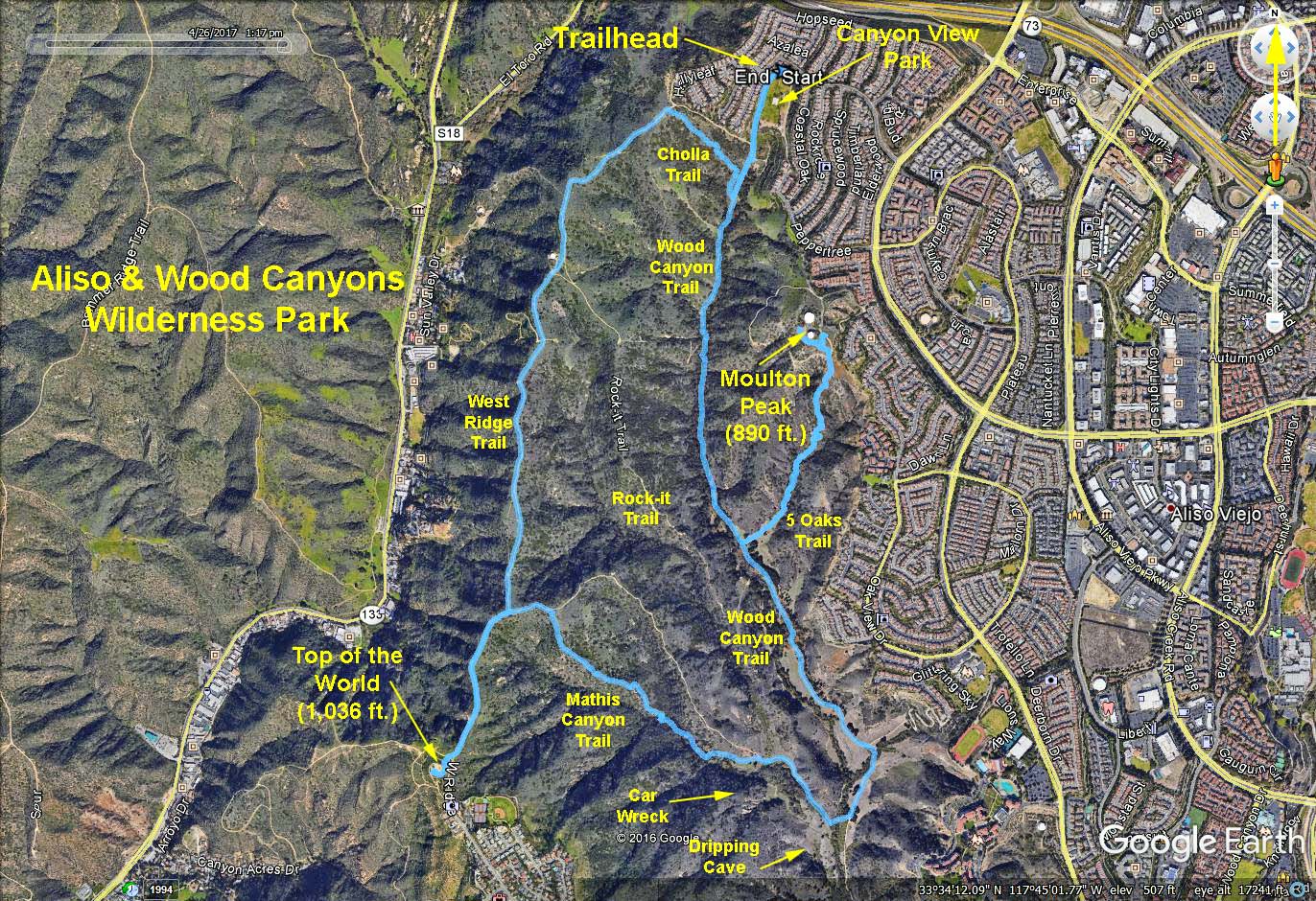
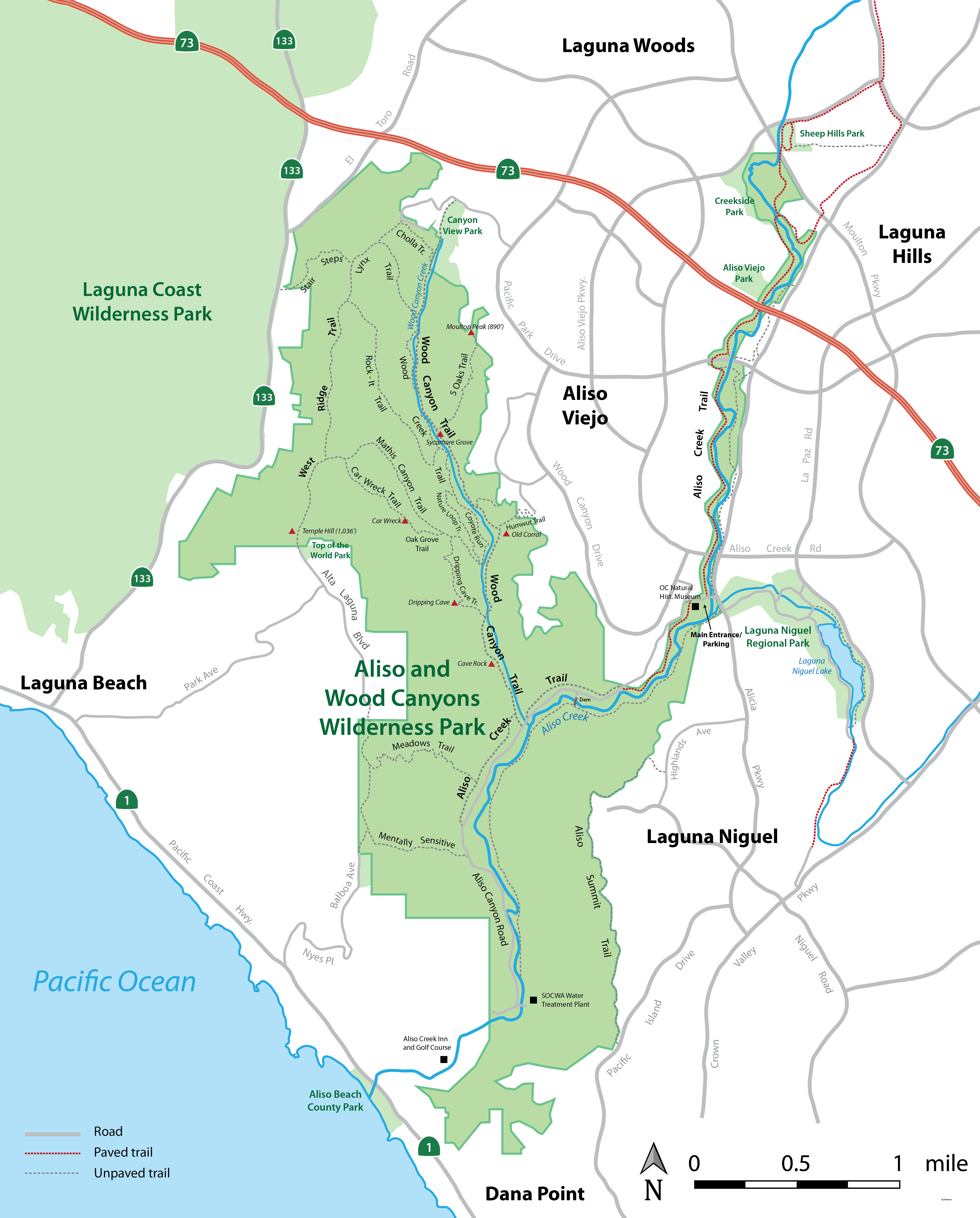
The Hike: We will start from, and return to, Canyon View Park, which has one upgraded port-a-potty and three picnic tables. There are occasional port-a-potties along the hike. The trailhead is reached by walking through the park to the rear right corner to a gate into the Wilderness Park. Excellent signage exists along the trails in the Wilderness Park. All hikes begin by walking through the city park to the entrance. After walking in the Wilderness Park a short distance we come to a bench and poster board, and a fork in the trail.
The baseline hike this time is a counterclockwise loop starting at the turnoff to the right on Cholla Trail, which we reach after we head south a short distance from the park. We take Cholla a few hundred feet uphill to the ridge of the hills and turn left (south) on West Ridge Trail. We hike West Ridge Trail past the Rock-it Trail (on the left) until the intersection with Mathis Canyon Trail. The loop to this point is about 1.8 miles. We turn left to go downhill (moderately steeply) southeast until Dripping Cave Trail. We turn right on this trail, which has moderate undulations, for the walk to Dripping Cave. This is a potential great spot for lunch. We then continue briefly to the end of Dripping Cave trail where it ends at Wood Canyon Trail (our main trail). This get us to about 3.5 miles on the loop. The baseline hike now turns left (north) following Wood Canyon Trail along Wood Creek, with shade, trees, creek, and meadow scenery, all the way back to Canyon View Park and the trailhead.
Several excellent hike alternatives exist here and will be explained, with a map, at the start of the hike.
One nice short extension is (1) about 0.3 mile further down (south) from Dripping cave to Cave Rock (and then return) or (2) continue a little further until we reach the end of this trail at Aliso Creek Trail, which is about 3.5 miles back to the trailhead.
Other hike extensions include (1) a half mile walk each way to Top of the World (for a panoramic view of Catalina, Palos Verdes, the San Gabriels, and San Clemente Island) by continuing on West Ridge Trail past the Mathis Trail turnoff, (2) up to 1.75 miles each way by walking along Aliso Creek Trail or possibly Meadows Trail at the end of Wood Canyon Trail, and (3) various little trail options along the way. Some of us like to hike the baseline hike in the opposite direction.
A Side Trip extension courtesy of Tom K: (Follow these instructions if you want a little excitement in your life.)
As you descend down Mathis Canyon Trail a short distance you will see a sign on your right for Car Wreck Trail. This trail is very steep and those w/ knee issues should avoid this. Car Wreck will take you down to the canyon floor in a much shorter distance than Mathis Canyon Trail. However, once near the bottom you will be rewarded with a sight not often seen; A 1940's auto of undetermined make or model embedded in the ground. How it got there no one seems to know. After viewing the car, continue east. You will soon connect with the Oak Grove Trail (a very scenic area). Oak Grove will then connect with Dripping Cave Trail. Then follow the main instructions to return to the trailhead.
Two suggested shorter hikes are (1) Go down Wood Canyon Trail to Dripping Cave and return (4.7 miles without much elevation gain, and in pretty, shaded scenery) and (2) a full 5 mile loop but that turns onto Mathis Canyon Trail and Wood Canyon Trail without side trips and without going all the way to Aliso Creek Trail .
Refreshments will be in the city park. Glass bottles and alcohol are prohibited, so all beverages will be in cans, and plastic cups will be provided.
Please bring the following maps, with you to the hike.
Google Earth - Aliso & Wood Canyons
Aliso & Wood Canyons Wilderness Park 1
Aliso & Wood Canyons Wilderness Park 2 (Note that map 2 shows the clockwise path done in hike #1217)
Distance: Baseline hike = 7.0 miles round trip. Elevation gain: 900 ft.
2017-07-16